


Only followers of this user (FalseProphet) can see their posts

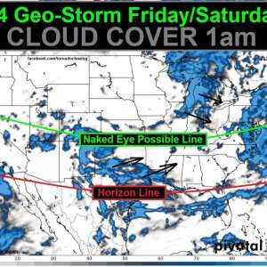
"A series of powerful solar flares and eruptions from the sun are set to trigger a severe geomagnetic storm, potentially bringing breathtaking displays of auroras, the northern lights, to skies across the United States this weekend."
Watch out this weekend 🌌☀️🌎🎆 #SolarStorms #Auroras #Stargazing
Watch out this weekend 🌌☀️🌎🎆 #SolarStorms #Auroras #Stargazing

03:46 PM - May 10, 2024

Hinds / Madison / Rankin MS
At 1016 PM CDT, a severe thunderstorm capable of producing a tornado was located over Bolton, 8 miles NW of Raymond, moving E at 30 mph.
Prepare to take shelter. underground / basement / interior room w/ head coverings / shoes.
#SpoutibleTornadoWarning
At 1016 PM CDT, a severe thunderstorm capable of producing a tornado was located over Bolton, 8 miles NW of Raymond, moving E at 30 mph.
Prepare to take shelter. underground / basement / interior room w/ head coverings / shoes.
#SpoutibleTornadoWarning

11:20 PM - May 09, 2024
McCulloch / Mason / San Saba TX
At 519 PM CDT, a severe thunderstorm capable of producing a tornado was located near Camp San Saba, moving SE at 35 mph.
Prepare to take shelter. underground / basement / interior room w/ head coverings / shoes.
#SpoutibleTornadoWarning
At 519 PM CDT, a severe thunderstorm capable of producing a tornado was located near Camp San Saba, moving SE at 35 mph.
Prepare to take shelter. underground / basement / interior room w/ head coverings / shoes.
#SpoutibleTornadoWarning

06:23 PM - May 09, 2024

DNA Tests are Uncovering the True Prevalence of Incest
This may sound off base, but Freud was wrong. There was a high degree of incest & sexual trauma. This trend continues.
#DNAtesting #incest #FamilyDynamics #abuse
This may sound off base, but Freud was wrong. There was a high degree of incest & sexual trauma. This trend continues.
#DNAtesting #incest #FamilyDynamics #abuse

05:12 AM - May 09, 2024
Murray / Walker / Whitfield GA
At 1051 PM EDT, a severe thunderstorm capable of producing a tornado was located over Suttles Mill + Lafayette, moving E at 35 mph.
Prepare to take shelter. underground / basement / interior room w/ head coverings / shoes.
#SpoutibleTornadoWarning
At 1051 PM EDT, a severe thunderstorm capable of producing a tornado was located over Suttles Mill + Lafayette, moving E at 35 mph.
Prepare to take shelter. underground / basement / interior room w/ head coverings / shoes.
#SpoutibleTornadoWarning

10:54 PM - May 08, 2024
Jackson / Madison AL
At 926 PM CDT, a tornado producing storm was located over E Huntsville, moving E at 35 mph.
Prepare to take shelter. underground / basement / interior room w/ head coverings / shoes.
#SpoutibleTornadoWarning
At 926 PM CDT, a tornado producing storm was located over E Huntsville, moving E at 35 mph.
Prepare to take shelter. underground / basement / interior room w/ head coverings / shoes.
#SpoutibleTornadoWarning

10:32 PM - May 08, 2024
Giles TN
At 756 PM CDT, a severe thunderstorm capable of producing a tornado was located 8 miles NW of Ardmore, 9 miles SE of Pulaski, moving E at 30 mph.
Prepare to take shelter. underground / basement / interior room w/ head coverings / shoes.
#SpoutibleTornadoWarning
At 756 PM CDT, a severe thunderstorm capable of producing a tornado was located 8 miles NW of Ardmore, 9 miles SE of Pulaski, moving E at 30 mph.
Prepare to take shelter. underground / basement / interior room w/ head coverings / shoes.
#SpoutibleTornadoWarning

09:01 PM - May 08, 2024
Marshall / Maury / Rutherford / Williamson TN
At 540 PM CDT, a severe thunderstorm capable of producing a tornado was located near Columbia, moving northeast at 30 mph.
Prepare to take shelter. underground / basement / interior room w/ head coverings / shoes.
#SpoutibleTornadoWarning
At 540 PM CDT, a severe thunderstorm capable of producing a tornado was located near Columbia, moving northeast at 30 mph.
Prepare to take shelter. underground / basement / interior room w/ head coverings / shoes.
#SpoutibleTornadoWarning

06:45 PM - May 08, 2024
Davidson / Robertson / Sumner TN
At 522 PM CDT, a severe thunderstorm capable of producing a tornado was located near Greenbrier, 7 miles S of Springfield, moving E at 30 mph.
Prepare to take shelter. underground / basement / interior room w/ head coverings / shoes.
#SpoutibleTornadoWarning
At 522 PM CDT, a severe thunderstorm capable of producing a tornado was located near Greenbrier, 7 miles S of Springfield, moving E at 30 mph.
Prepare to take shelter. underground / basement / interior room w/ head coverings / shoes.
#SpoutibleTornadoWarning

06:31 PM - May 08, 2024
Cheatham / Robertson TN
At 459 PM CDT, a severe thunderstorm capable of producing a tornado was located near Coopertown, 9 miles W of Springfield, moving E at 25 mph.
Prepare to take shelter. underground / basement / interior room w/ head coverings / shoes.
#SpoutibleTornadoWarning
At 459 PM CDT, a severe thunderstorm capable of producing a tornado was located near Coopertown, 9 miles W of Springfield, moving E at 25 mph.
Prepare to take shelter. underground / basement / interior room w/ head coverings / shoes.
#SpoutibleTornadoWarning

06:11 PM - May 08, 2024
Cheatham / Robertson TN
At 459 PM CDT, a severe thunderstorm capable of producing a tornado was located near Coopertown, 9 miles W of Springfield, moving E at 25 mph.
Prepare to take shelter. underground / basement / interior room w/ head coverings / shoes.
#SpoutibleTornadoWarning
At 459 PM CDT, a severe thunderstorm capable of producing a tornado was located near Coopertown, 9 miles W of Springfield, moving E at 25 mph.
Prepare to take shelter. underground / basement / interior room w/ head coverings / shoes.
#SpoutibleTornadoWarning

06:02 PM - May 08, 2024


Barry / Christian / Lawrence / Stone MO
At 428 PM CDT, a severe thunderstorm capable of producing a tornado was located near Monett, moving E at 35 mph.
Prepare to take shelter. underground / basement / interior room w/ head coverings / shoes.
#SpoutibleTornadoWarning
At 428 PM CDT, a severe thunderstorm capable of producing a tornado was located near Monett, moving E at 35 mph.
Prepare to take shelter. underground / basement / interior room w/ head coverings / shoes.
#SpoutibleTornadoWarning
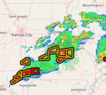
05:31 PM - May 08, 2024
Hickman / Lewis / Maury TN
At 442 PM CDT, a severe thunderstorm capable of producing a tornado was located over Hohenwald, moving NE at 40 mph.
Prepare to take shelter. underground / basement / interior room w/ head coverings / shoes.
#SpoutibleTornadoWarning
At 442 PM CDT, a severe thunderstorm capable of producing a tornado was located over Hohenwald, moving NE at 40 mph.
Prepare to take shelter. underground / basement / interior room w/ head coverings / shoes.
#SpoutibleTornadoWarning
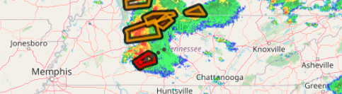
05:46 PM - May 08, 2024
Gallatin / Saline IL
At 412 PM CDT, a severe thunderstorm capable of producing a tornado was located +/- 5 miles S of Harrisburg, moving E at 35 mph. The tornadic part of the storm should stay south of Harrisburg.
Take shelter: underground / basement / interior room.
#SpoutibleTornadoWarning
At 412 PM CDT, a severe thunderstorm capable of producing a tornado was located +/- 5 miles S of Harrisburg, moving E at 35 mph. The tornadic part of the storm should stay south of Harrisburg.
Take shelter: underground / basement / interior room.
#SpoutibleTornadoWarning

05:18 PM - May 08, 2024
Johnson / Pope / Saline / Williamson IL
At 417 PM CDT, A CONFIRMED TORNADO was located over Creal Springs, 9 miles SE of Marion, moving E at 30 mph.
TAKE SHELTER NOW: underground / basement / interior room w/ head coverings / shoes. Beware flying debris.
#SpoutibleTornadoWarning
At 417 PM CDT, A CONFIRMED TORNADO was located over Creal Springs, 9 miles SE of Marion, moving E at 30 mph.
TAKE SHELTER NOW: underground / basement / interior room w/ head coverings / shoes. Beware flying debris.
#SpoutibleTornadoWarning

05:21 PM - May 08, 2024
Hardin / Crittenden / Union IL / KY
At 418 PM CDT, a severe thunderstorm capable of producing a tornado was located near Rosiclare, 17 miles SW of Shawneetown, moving E at 40 mph.
Prepare to take shelter. underground / basement / interior room.
#SpoutibleTornadoWarning
At 418 PM CDT, a severe thunderstorm capable of producing a tornado was located near Rosiclare, 17 miles SW of Shawneetown, moving E at 40 mph.
Prepare to take shelter. underground / basement / interior room.
#SpoutibleTornadoWarning

05:23 PM - May 08, 2024
Lewis / Perry / Wayne TN
At 417 PM CDT, a severe thunderstorm capable of producing a tornado was located 8 miles N of Waynesboro, moving NE at 35 mph.
Prepare to take shelter. underground / basement / interior room w/ head coverings / shoes.
#SpoutibleTornadoWarning
At 417 PM CDT, a severe thunderstorm capable of producing a tornado was located 8 miles N of Waynesboro, moving NE at 35 mph.
Prepare to take shelter. underground / basement / interior room w/ head coverings / shoes.
#SpoutibleTornadoWarning

05:24 PM - May 08, 2024
Caldwell / Christian KY
At 423 PM CDT, a severe thunderstorm capable of producing a tornado was located near Princeton, moving E at 30 mph.
Prepare to take shelter. underground / basement / interior room w/ head coverings / shoes.
#SpoutibleTornadoWarning
At 423 PM CDT, a severe thunderstorm capable of producing a tornado was located near Princeton, moving E at 30 mph.
Prepare to take shelter. underground / basement / interior room w/ head coverings / shoes.
#SpoutibleTornadoWarning

05:26 PM - May 08, 2024
Licking OH
1115 PM EDT, a severe thunderstorm capable of producing a tornado was located over Johnstown, moving E at 40 mph.
Prepare to take shelter. underground / basement / interior room w/ head coverings / shoes.
#SpoutibleTornadoWarning
1115 PM EDT, a severe thunderstorm capable of producing a tornado was located over Johnstown, moving E at 40 mph.
Prepare to take shelter. underground / basement / interior room w/ head coverings / shoes.
#SpoutibleTornadoWarning

11:20 PM - May 07, 2024
Greene / Lawrence / Martin / Monroe IN
At 1107 PM EDT, a severe thunderstorm capable of producing a tornado was located 11 miles SE of Bloomfield, 15 miles W of Bedford, moving E at 45 mph.
Prepare to take shelter. underground / basement / interior room.
#SpoutibleTornadoWarning
At 1107 PM EDT, a severe thunderstorm capable of producing a tornado was located 11 miles SE of Bloomfield, 15 miles W of Bedford, moving E at 45 mph.
Prepare to take shelter. underground / basement / interior room.
#SpoutibleTornadoWarning

11:19 PM - May 07, 2024
Daviess / Knox IN
At 1042 PM EDT, a severe thunderstorm capable of producing a tornado was located near Russellville + Vincennes, moving E at 25 mph.
Prepare to take shelter. underground / basement / interior room w/ head coverings / shoes.
#SpoutibleTornadoWarning
At 1042 PM EDT, a severe thunderstorm capable of producing a tornado was located near Russellville + Vincennes, moving E at 25 mph.
Prepare to take shelter. underground / basement / interior room w/ head coverings / shoes.
#SpoutibleTornadoWarning

10:44 PM - May 07, 2024
Delaware / Franklin / Licking OH
At 1039 PM EDT, a severe thunderstorm capable of producing a tornado was located over Dublin, moving E at 35 mph.
Prepare to take shelter. underground / basement / interior room w/ head coverings / shoes.
#SpoutibleTornadoWarning
At 1039 PM EDT, a severe thunderstorm capable of producing a tornado was located over Dublin, moving E at 35 mph.
Prepare to take shelter. underground / basement / interior room w/ head coverings / shoes.
#SpoutibleTornadoWarning
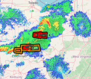
10:42 PM - May 07, 2024
Lawrence IL
At 920 PM CDT, a severe thunderstorm capable of producing a tornado was located over Lawrenceville, moving E at 30 mph.
Prepare to take shelter. underground / basement / interior room w/ head coverings / shoes.
#SpoutibleTornadoWarning
At 920 PM CDT, a severe thunderstorm capable of producing a tornado was located over Lawrenceville, moving E at 30 mph.
Prepare to take shelter. underground / basement / interior room w/ head coverings / shoes.
#SpoutibleTornadoWarning

10:22 PM - May 07, 2024
Delaware / Franklin / Madison / Union OH
At 1011 PM EDT, a severe thunderstorm capable of producing a tornado was located near Mechanicsburg, moving E at 40 mph.
Prepare to take shelter. underground / basement / interior room w/ head coverings / shoes.
#SpoutibleTornadoWarning
At 1011 PM EDT, a severe thunderstorm capable of producing a tornado was located near Mechanicsburg, moving E at 40 mph.
Prepare to take shelter. underground / basement / interior room w/ head coverings / shoes.
#SpoutibleTornadoWarning

10:18 PM - May 07, 2024
Champaign / Logan OH
At 928 PM EDT, a severe thunderstorm capable of producing a tornado was located near St Paris, moving E at 40 mph.
Prepare to take shelter. underground / basement / interior room w/ head coverings / shoes.
#SpoutibleTornadoWarning
At 928 PM EDT, a severe thunderstorm capable of producing a tornado was located near St Paris, moving E at 40 mph.
Prepare to take shelter. underground / basement / interior room w/ head coverings / shoes.
#SpoutibleTornadoWarning

09:31 PM - May 07, 2024
Decatur IN
At 921 PM EDT, a severe thunderstorm capable of producing a tornado was located near Greensburg, 18 miles W of Batesville, moving E at 30 mph.
Prepare to take shelter. underground / basement / interior room w/ head coverings / shoes.
#SpoutibleTornadoWarning
At 921 PM EDT, a severe thunderstorm capable of producing a tornado was located near Greensburg, 18 miles W of Batesville, moving E at 30 mph.
Prepare to take shelter. underground / basement / interior room w/ head coverings / shoes.
#SpoutibleTornadoWarning

09:28 PM - May 07, 2024
Dearborn / Franklin / Ripley IN
At 924 PM EDT, a severe thunderstorm capable of producing a tornado was located near Batesville, moving E at 40 mph.
Prepare to take shelter. underground / basement / interior room w/ head coverings / shoes.
#SpoutibleTornadoWarning
At 924 PM EDT, a severe thunderstorm capable of producing a tornado was located near Batesville, moving E at 40 mph.
Prepare to take shelter. underground / basement / interior room w/ head coverings / shoes.
#SpoutibleTornadoWarning

09:29 PM - May 07, 2024