
National Weather Service - Weather Prediction Center - College Park, MD - 04/24/2024
Isolated Severe Thunderstorms in the Southern Plains
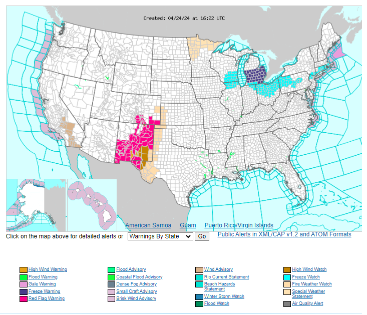
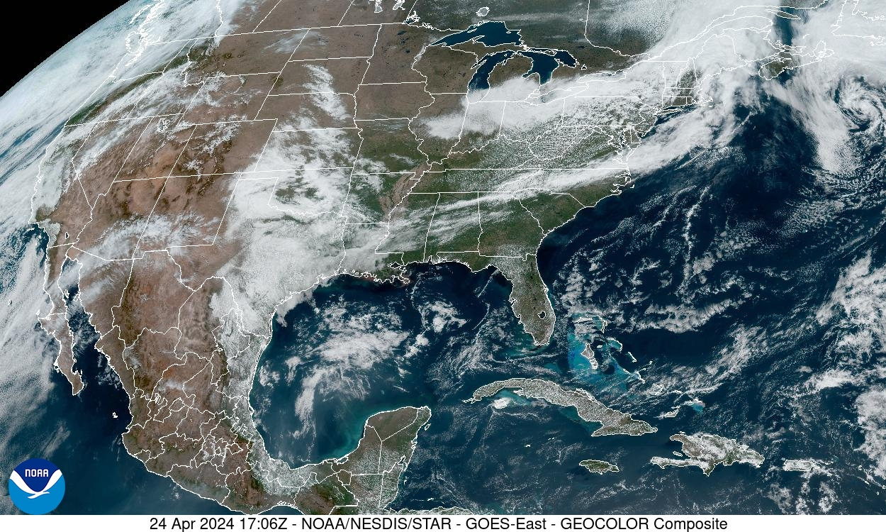
A few isolated severe thunderstorms may develop across the southern High Plains + Lower Mississippi Valley later today.
#SpoutibleWeatherWatch
Isolated Severe Thunderstorms in the Southern Plains
A few isolated severe thunderstorms may develop across the southern High Plains + Lower Mississippi Valley later today.
#SpoutibleWeatherWatch
12:35 PM - Apr 24, 2024
National Weather Service - Weather Prediction Center - College Park, MD - 04/24/2024
Fire Weather for New Mexico + Southern Colorado Combination dry conditions + gusty winds bring critical fire weather to New Mexico + southern Colorado through the weekend.
#SpoutibleWeatherWatch
Fire Weather for New Mexico + Southern Colorado Combination dry conditions + gusty winds bring critical fire weather to New Mexico + southern Colorado through the weekend.
#SpoutibleWeatherWatch
12:37 PM - Apr 24, 2024
NWS - Weather Prediction Center - College Park, MD - 04/24/2024
National Digital Forecast - High Temperatures
Above average temperatures shift from the Great Basin to the Plains...
The West + East remain cool through the end of the week...
#SpoutibleWeatherWatch
National Digital Forecast - High Temperatures
Above average temperatures shift from the Great Basin to the Plains...
The West + East remain cool through the end of the week...
#SpoutibleWeatherWatch
12:40 PM - Apr 24, 2024
NWS - Weather Prediction Center - 04/24/2024
A cooling trend is expected throughout the West compared to the spring warmth felt the last few days.
Chilly weather is expected across the NE through the end of the week as high pressure moves south from Canada.
#SpoutibleWeatherWatch
A cooling trend is expected throughout the West compared to the spring warmth felt the last few days.
Chilly weather is expected across the NE through the end of the week as high pressure moves south from Canada.
#SpoutibleWeatherWatch
12:44 PM - Apr 24, 2024
NWS - Weather Prediction Center - 04/24/2024
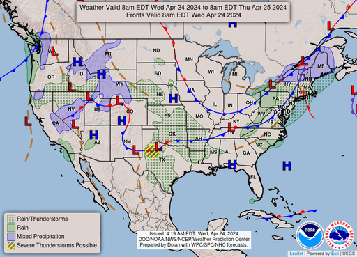
Low temperatures may dip below freezing on Thursday morning, prompting Freeze Watches to be issued from the Lower Great Lakes to southern New England. Protect tender plants...
#SpoutibleWeatherWatch
Low temperatures may dip below freezing on Thursday morning, prompting Freeze Watches to be issued from the Lower Great Lakes to southern New England. Protect tender plants...
#SpoutibleWeatherWatch
12:45 PM - Apr 24, 2024
(Edited)
NWS - Weather Prediction Center - 04/24/2024
Above average warmth will be found throughout the Plains w/ highs into the 80s across the Southern Tier States until Friday.
#SpoutibleWeatherWatch
Above average warmth will be found throughout the Plains w/ highs into the 80s across the Southern Tier States until Friday.
#SpoutibleWeatherWatch
12:47 PM - Apr 24, 2024
NWS - WPC - 04/24/2024
Unsettled weather + severe thunderstorms are possible across much of the central United States over the next several days...
An active fire weather pattern settles over the southern High
Plains...
#SpoutibleWeatherWatch
Unsettled weather + severe thunderstorms are possible across much of the central United States over the next several days...
An active fire weather pattern settles over the southern High
Plains...
#SpoutibleWeatherWatch
12:49 PM - Apr 24, 2024
NWS - WPC - 04/24/2024
A ripe Spring severe weather pattern is setting up over the central + southern Plains. A trough will enter the Southwest early Thursday + swing into the central Plains by Friday as moisture from the Gulf of Mexico begins to drift northward today.
#SpoutibleWeatherWatch
A ripe Spring severe weather pattern is setting up over the central + southern Plains. A trough will enter the Southwest early Thursday + swing into the central Plains by Friday as moisture from the Gulf of Mexico begins to drift northward today.
#SpoutibleWeatherWatch
12:53 PM - Apr 24, 2024
NWS - WPC - 04/24/2024
Developing thunderstorms may turn severe today from West Texas to central Oklahoma bringing isolated flash flooding.
Thursday will see numerous thunderstorms across the central + southern Plains w/ scattered storms turning severe.
#SpoutibleWeatherWatch
Developing thunderstorms may turn severe today from West Texas to central Oklahoma bringing isolated flash flooding.
Thursday will see numerous thunderstorms across the central + southern Plains w/ scattered storms turning severe.
#SpoutibleWeatherWatch
12:56 PM - Apr 24, 2024
NWS - WPC - 04/24/2024
Severe weather is expected across parts of SW/S-central Kansas, W Oklahoma + the E Texas Panhandle. Very large hail, severe wind gusts + a couple strong tornadoes will be possible. Multiple rounds of heavy rain may also lead to flash flooding,
#SpoutibleWeatherWatch
Severe weather is expected across parts of SW/S-central Kansas, W Oklahoma + the E Texas Panhandle. Very large hail, severe wind gusts + a couple strong tornadoes will be possible. Multiple rounds of heavy rain may also lead to flash flooding,
#SpoutibleWeatherWatch
12:59 PM - Apr 24, 2024
NWS - WPC - 04/24/2024
Heavy rain is expected for NE Oklahoma, E Kansas, W Missouri + NW Arkansas Thursday.
By Friday, this system will slide E into the central Plains w/ showers + thunderstorms moving into the Upper Midwest, Middle / Lower Mississippi Valley + S Plains.
#SpoutibleWeatherWatch
Heavy rain is expected for NE Oklahoma, E Kansas, W Missouri + NW Arkansas Thursday.
By Friday, this system will slide E into the central Plains w/ showers + thunderstorms moving into the Upper Midwest, Middle / Lower Mississippi Valley + S Plains.
#SpoutibleWeatherWatch
01:03 PM - Apr 24, 2024
NWS - WPC - 04/24/2024
The southern High Plains, w/ combination very low relative humidity + gusty winds, will see Critical Fire Weather on Thursday + Friday. Fires that develop will spread rapidly. Outdoor burning is not advised. Gusty 55 mph winds will create blowing dust.
#SpoutibleWeatherWatch
The southern High Plains, w/ combination very low relative humidity + gusty winds, will see Critical Fire Weather on Thursday + Friday. Fires that develop will spread rapidly. Outdoor burning is not advised. Gusty 55 mph winds will create blowing dust.
#SpoutibleWeatherWatch
01:11 PM - Apr 24, 2024
NWS - WPC - 04/24/2024
A cold front crossing the Northeast today will spread showers over the region. Snow showers are possible across northern New England.
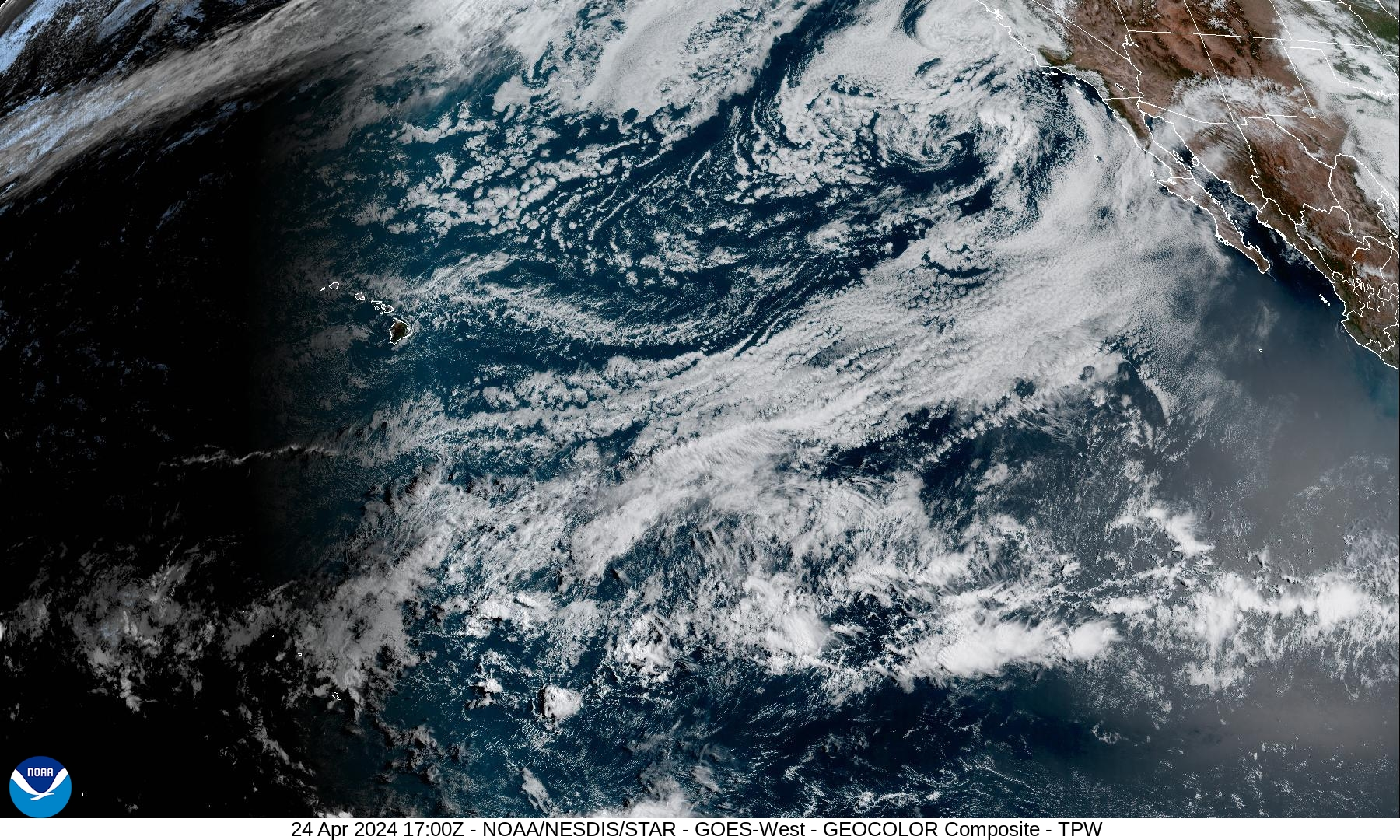
Unsettled weather is expected to develop over the West, Great Basin + Rockies over the next few days.
#SpoutibleWeatherWatch
A cold front crossing the Northeast today will spread showers over the region. Snow showers are possible across northern New England.
Unsettled weather is expected to develop over the West, Great Basin + Rockies over the next few days.
#SpoutibleWeatherWatch
01:14 PM - Apr 24, 2024
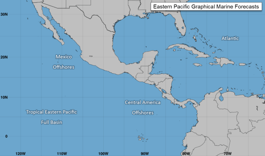
National Weather Service - National Hurricane Center - Miami, FL - 04/24/2024
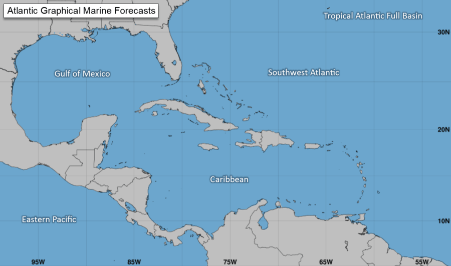
Atlantic - Caribbean Sea - Gulf of Mexico
There are no tropical cyclones in the Atlantic at this time.
Mainly gentle to moderate E to SE winds prevail across the Gulf basin.
#SpoutibleWeatherWatch
Atlantic - Caribbean Sea - Gulf of Mexico
There are no tropical cyclones in the Atlantic at this time.
Mainly gentle to moderate E to SE winds prevail across the Gulf basin.
#SpoutibleWeatherWatch
01:21 PM - Apr 24, 2024
NWS - National Hurricane Center - 04/24/2024
The broad ridge centered off NE Florida will support mainly gentle to moderate E winds + 1 to 3 ft seas in the NE half of the Gulf basin + moderate to fresh SE winds + 2 to 4 ft seas in the SW half of the Gulf basin through Thu.
#SpoutibleWeatherWatch
The broad ridge centered off NE Florida will support mainly gentle to moderate E winds + 1 to 3 ft seas in the NE half of the Gulf basin + moderate to fresh SE winds + 2 to 4 ft seas in the SW half of the Gulf basin through Thu.
#SpoutibleWeatherWatch
01:25 PM - Apr 24, 2024
NWS - NHC - 04/24/2024
Eastern North Pacific
There are no tropical cyclones in the Eastern North Pacific at this time.
The Gulf of California has gentle to moderate northerly winds w/ seas of 4 to 6 ft west of Baja California.
#SpoutibleWeatherWatch
Eastern North Pacific
There are no tropical cyclones in the Eastern North Pacific at this time.
The Gulf of California has gentle to moderate northerly winds w/ seas of 4 to 6 ft west of Baja California.
#SpoutibleWeatherWatch
01:32 PM - Apr 24, 2024
NWS - NHC - 04/24/2024
Fresh S to SW winds in the N Gulf of California will diminish to moderate speeds this afternoon.
Strong high pressure building E of Baja California will cause gentle to moderate northerly winds + building seas W of Baja CA beginning this afternoon.
#SpoutibleWeatherWatch
Fresh S to SW winds in the N Gulf of California will diminish to moderate speeds this afternoon.
Strong high pressure building E of Baja California will cause gentle to moderate northerly winds + building seas W of Baja CA beginning this afternoon.
#SpoutibleWeatherWatch
01:37 PM - Apr 24, 2024